
When Hurricane Polo intensified into one of the strongest and longest-lasting Category 5 hurricanes recorded in the eastern Pacific in September 2026, an exceptionally strong El Niño seemed the obvious explanation. But a rapid scientific analysis released on October 15 found that human-caused climate change had an even greater influence than El Niño on the ocean and atmospheric conditions that allowed Polo to become so extreme.
The distinction matters because El Niño is a temporary climate pattern, while human-caused warming keeps raising the planet’s long-term temperature baseline. That means conditions capable of supporting an exceptionally intense hurricane can keep becoming more likely, even in years when El Niño is absent altogether.
Title: Effect of climate change at least as large as El Niño in strengthening Hurricane Polo
Authors: Friederike Otto et al. (World Weather Attribution / Climate Central)
Journal: World Weather Attribution rapid report, Grantham Institute, Imperial College London (not yet peer-reviewed)
DOI: 10.25560/144926
A Record-Breaking Storm, Dissected
Hurricane Polo intensified explosively over the eastern Pacific in late September 2026, with maximum sustained winds climbing by roughly 90 knots (about 167 km/h) in 24 hours — a jump the US National Hurricane Center called “truly remarkable.” The storm peaked at about 165 mph (265 km/h), Category 5 strength, and the Associated Press described it as the longest-lasting Category 5 storm on record in the Pacific. Polo went on to make landfall in Mexico’s Baja California Sur and cross into Sonora, and the flooding that followed killed at least five people across Jalisco and Sonora, according to local reports cited in the WWA assessment; roughly 1,000 people were evacuated in New Mexico over fears a dam could fail.
As soon as the storm weakened, World Weather Attribution (WWA) — the international scientist network known for analyzing extreme weather events within days of them happening, rather than waiting years for a full peer-reviewed study — teamed up with the nonprofit Climate Central to work out how much of Polo’s power came from decades of ocean warming versus this year’s unusually strong El Niño. The team included researchers based in Mexico, the United States, the United Kingdom, Ireland and the Netherlands, working with partners at Imperial College London, the Royal Netherlands Meteorological Institute (KNMI) and the Red Cross Red Crescent Climate Centre.
Three Ways to Measure the Effect
To separate the two influences, the researchers mainly relied on a measure called “potential intensity” — a thermodynamic estimate, built from sea-surface temperature, air temperature and humidity, of the strongest a storm could theoretically become in a given patch of ocean. It is not a prediction of the exact wind speed a real storm will reach, since that also depends on wind shear, storm structure and other factors. The team compared potential intensity in the real, warmed-up world against a hypothetical world without human-caused warming, and separately against a world without this year’s El Niño.
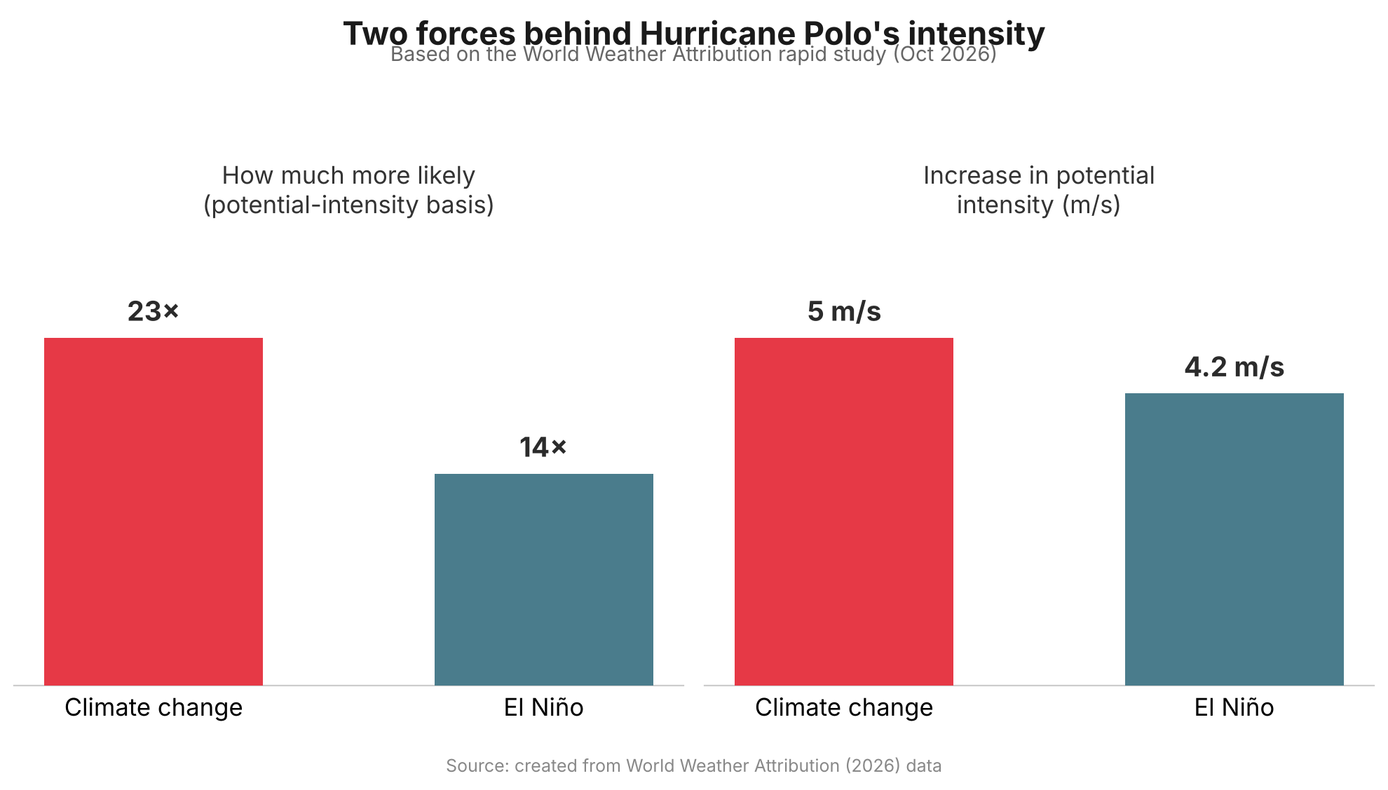
The results point the same way on multiple measures. Conditions associated with Polo’s extreme potential intensity were estimated to be about 23 times more likely in today’s climate than in a world without human-caused warming — roughly a 1-in-115-year event — compared with about 14 times more likely from this year’s El Niño relative to neutral conditions, roughly a 1-in-70-year event. In terms of potential intensity itself, climate change added an estimated 5 m/s, versus about 4.2 m/s from El Niño. Separately, the researchers estimated that climate change increased Polo’s actual peak wind speed by about 2.7 m/s, or roughly 6 mph. The ocean water Polo crossed was also assessed on its own: it was about 1.4°C warmer than it would have been in a pre-industrial climate, a level of warmth made roughly 100 to 200 times more likely by climate change.
Why a Few Miles an Hour Matters
A few extra miles per hour might not sound dramatic, but it is not a small thing physically. The kinetic energy wind carries rises roughly with the cube of its speed, so a modest increase in wind speed can translate into a disproportionately larger jump in the force a storm can exert — even before accounting for how a particular coastline’s buildings, storm surge and terrain shape the actual damage. That nonlinearity is why hurricane scientists pay close attention to marginal gains in wind speed, and why researchers note that a storm carrying Polo’s extra climate-driven intensity toward a more densely populated coastline could have caused significantly more damage than it did striking a relatively sparsely populated stretch of Mexico.
El Niño Fades, Warming Doesn’t
“El Niño comes and goes, but climate change only gets worse.”
That line, from WWA’s Friederike Otto, captures why the study’s authors consider the finding noteworthy even though El Niño’s own contribution was substantial. El Niño is a natural, temporary swing in Pacific Ocean temperatures that typically lasts anywhere from several months to a year or more before fading. Climate Central’s Daniel Gilford has compared the two influences to a traffic light and an accelerator: in some regions, El Niño can reduce the high-altitude wind shear that would otherwise tear a storm apart, acting like a green light, while warmer ocean water supplies extra heat and moisture that fuel a storm once it starts to intensify. Neither factor guarantees a storm will intensify, but the light will eventually turn red again as El Niño fades. The long-term warming trend, tied to the heat still accumulating in the climate system, does not reset the same way.
What the Study Can and Can’t Show
The analysis has not yet been peer-reviewed, which is standard for WWA’s rapid-response studies — the trade-off the group accepts in order to publish within days of a disaster rather than months later. The researchers also tried to quantify climate change’s effect on Polo’s extreme rainfall, but found that available climate models could not reproduce historical rainfall trends in the region closely enough to draw a reliable conclusion, so they left that question open rather than guess.
Separately, the Associated Press reported that several hurricane scientists not involved in the study — including Jeff Masters, Michael Mann and Carl Schreck — have suggested the climate-change contribution to Polo could be an underestimate, pointing to a 2024 study by Gilford that found climate change added as much as 16 mph to some Atlantic hurricanes. Gilford, a co-author of the new Polo study, told the AP he sees the new analysis as a deliberately conservative one. Either way, the study’s authors are careful to say it shows that a warmer world raised the odds of extreme conditions for this particular storm — not that every future hurricane will necessarily be stronger than the ones before it.
What This Means Going Forward
Polo fits a broader pattern this blog has covered before: this year’s global climate indicators report found that seven of sixteen tracked planetary vital signs hit record extremes in 2026, with warming accelerating rather than leveling off. Polo’s real significance may be less about one storm and more about the baseline it was built on. El Niño years will keep arriving and receding on their own schedule, occasionally stacking with warm oceans to produce an especially intense storm. But because the underlying warming trend persists between those cycles, each future El Niño has a slightly warmer ocean to draw on than the last one did — which is exactly the mechanism this study was designed to isolate.
Sources: World Weather Attribution, The Associated Press (via KSAT), NASA Earth Observatory, Full study (Imperial College London)